by dirwiz on 2/27/17, 3:18 PM with 83 comments
by Animats on 2/27/17, 5:58 PM
The original Etak units always had the map oriented with north at the top. That was the way sailors used maps. Honey said they'd discovered that about 20% of the population could not cope with a map that wasn't aligned with the direction they were going, which is why they started rotating the map based on vehicle travel. Now everybody does that, and that's why.
by DonHopkins on 2/27/17, 7:19 PM
The story of how TomTom and not Garmin ended up owning the data originally digitized at Etak is interesting. At the time, there were only two digital map companies: Tele Atlas (from which TomTom got their map data) and Navteq (from which Garmin got their map data).
From Wikipedia [1]:
"On July 23, 2007, a €2 billion offer for the company by navigation system maker TomTom was accepted by the Tele Atlas board. This was then trumped by a €2.3 billion offer from United States-based rival Garmin on October 31, 2007 initiating a bidding war for Tele Atlas. TomTom responded by upping their bid to €2.9 billion, an offer which was again approved by the board of Tele Atlas. Garmin had been expected to counterbid once again: with Tele Atlas' main global rival Navteq subject to a takeover bid from Nokia, the company had stated that it did not wish both companies to fall into the hands of rivals. However, after striking a content agreement with Navteq through the year 2015, Garmin withdrew its takeover offer, clearing the way for TomTom. On December 4, 2007, TomTom shareholders approved the takeover. The European Commissioner for Competition cleared the takeover in May 2008, and it closed in June."
TomTom (where I worked at the time) was shocked and dismayed that Garmin outbid them by €300 million on Tele Atlas, because while it made a lot of sense for TomTom to buy their own map data supplier, it would have been prohibitively complex and expensive for Garmin, who used Navteq data, to switch map data sources and retool their entire map data digestion, distribution and error correction pipelines.
TomTom was so determined to buy Tele Atlas and keep it out of Garmin's hands, that they raised their bid by €900 million.
In the meantime, Garmin renegotiated their deal with Navteq, so they didn't have to pay as much for the data, and didn't have to switch map suppliers.
The stunt that Garmin pulled of was, in my opinion, an ingenious head-fake that cost TomTom an enormous amount of money, almost a billion euros, and at the same time saved Garmin a whole lot of money by enabling them to renegotiate a better deal with Navteq, who was faced with losing their major customer if they didn't lower their prices.
by theamk on 2/27/17, 5:46 PM
"the system continuously ironed out accumulated errors over time by comparing actual distances driven and turns made with road shapes on the map. Honey calls the technique "augmented dead reckoning."
That means driving through a long stretch of straight highway could begin to trip up Etak's system, since there were no turns and no distinct roads for the computer to algorithmically seize upon. If that happened, the driver could manually reposition the car cursor onto a location on the map using controls on the display."
Those things work, but they are barely "good enough". The biggest problem is, it is easy to lose your position if you are in the city -- maybe you had a few sharp turns, went around the parking cars a couple of times. And once this happens, the system is unlikely to correct itself, your only way will be to manually set position, which most people will not do.
by shagie on 2/28/17, 12:53 AM
Picture driving a snow plow in the California sierras in whiteout conditions. On one side of you is a steep cliff with no guard rails (not that guard rails would - the snow is higher than the rails).
So, they embedded magnets in the road that had data in them (the way they were organized):
> Two primary technologies are being used in the ASP: detecting the plow's position relative to the center of the lane, to assist the operator in steering; and detecting obstacles, for collision warning. PATH's magnetic marker guidance system provides guidance information. This system was developed for automated vehicle guidance and control applications. A single magnetometer array comprised of seven magnetic sensors was installed at the front of the snowplow. Signal processing of the magnetometers provides lateral position measurement relative to the center of the lane, longitudinal position relative to mileposts, and yaw angle estimate. Binary coding of the magnetic markers when installed (north pole up vs. south pole up) also provides information about roadway characteristics, e.g. the direction and radius of the curves. The obstacle detection system uses a commercially available Eaton-Vorad radar, incorporating a digital interface developed by AHMCT in conjunction with Eaton Vorad.
by mzs on 2/27/17, 5:17 PM
http://world.honda.com/history/challenge/1981navigationsyste...
by teddyh on 2/27/17, 5:08 PM
by CalChris on 2/28/17, 2:32 AM
He's won the Jules Verne trophy as navigator, fastest round the world (48 days). He's won the Volvo. PacCup with Nolan Bushnell. Rolex Yachtsman of the year (his wife Sally has won twice). He did the NFL line effects, same for NASCAR and NHL. He did the Americas Cup effects. He did Sailmail. Multiple patents.
And he's an incredibly nice guy. Dennis Connor is the best American yachtsman, but Honey ain't far behind.
by twic on 2/27/17, 10:14 PM
Ah yes, the Polynesian stick charts:
by oh_sigh on 2/27/17, 7:10 PM
by strictnein on 2/27/17, 7:42 PM
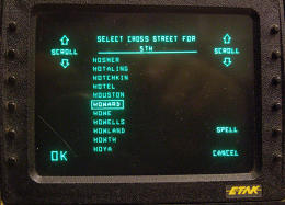
https://b.fastcompany.net/multisite_files/fastcompany/imagec...
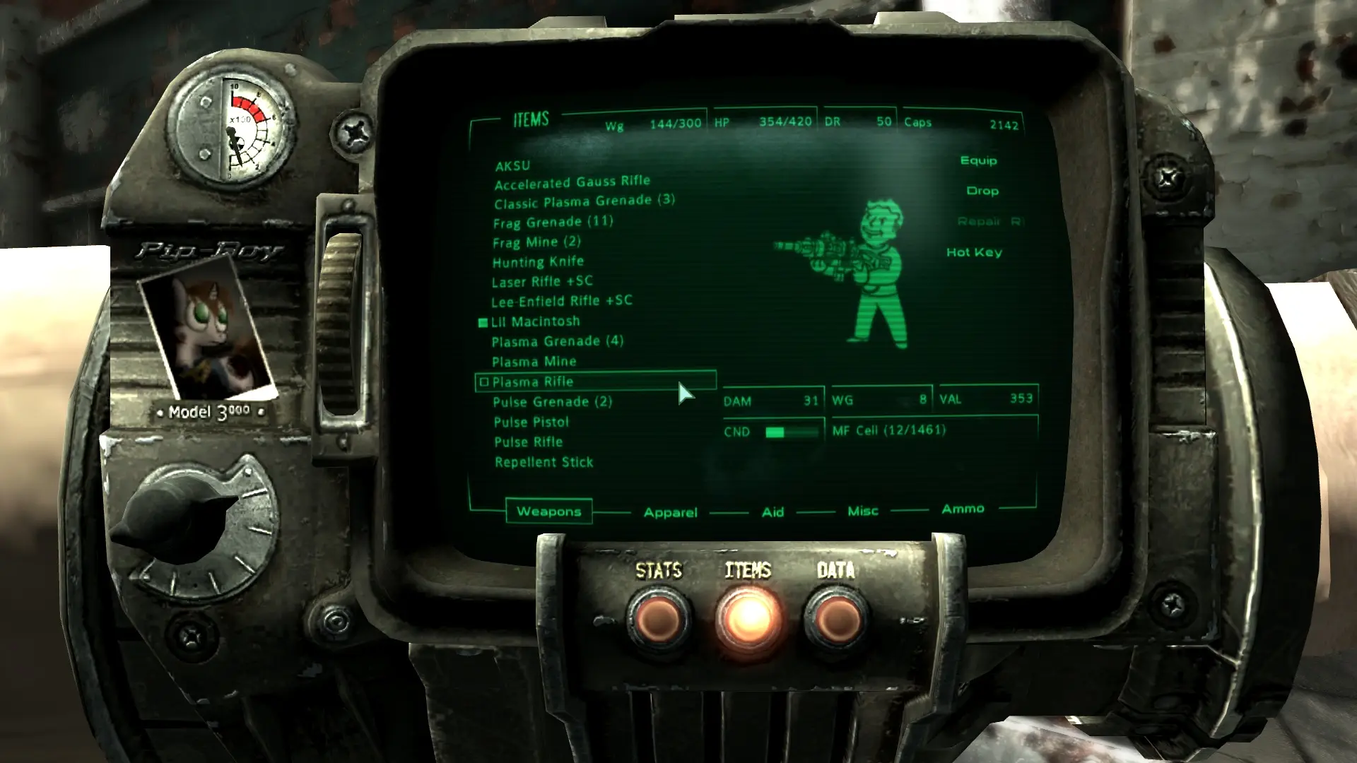
And a Fallout Pip Boy for reference: https://staticdelivery.nexusmods.com/mods/120/images/16096-1...
by anfractuosity on 2/27/17, 6:29 PM
If anyone has any up to date information or papers on this approach, I'd be very interested.
(It seems to be also known as a quantum compass)
by neotek on 2/28/17, 3:56 AM
I truly believe he is as much a visionary as Steve Jobs ever was, the difference being that Jobs had the patience to wait for technology to catch up to his vision, whereas Bushnell did his level best to invent it.
by squarefoot on 2/28/17, 2:47 PM
by kilroy123 on 2/27/17, 6:52 PM
by yvsong on 2/27/17, 8:59 PM
by guyzero on 2/27/17, 6:23 PM